


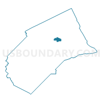
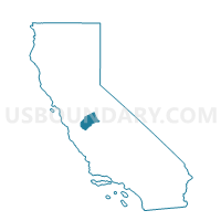
Voting District 30270, Merced County, California
About
Outline

Summary
| Unique Area Identifier | 535142 |
| Name | Voting District 30270 |
| County | Merced County |
| State | California |
| Area (square miles) | 9.19 |
| Land Area (square miles) | 9.11 |
| Water Area (square miles) | 0.07 |
| % of Land Area | 99.19 |
| % of Water Area | 0.81 |
| Latitude of the Internal Point | 37.30967730 |
| Longtitude of the Internal Point | -120.56655800 |
Maps

Graphs
Select a template below for downloading or customizing gragh for Voting District 30270, Merced County, California


Neighbors
Neighoring Voting District (by Name) Neighboring Voting District on the Map
- Voting District 10010, Merced County, CA
- Voting District 10080, Merced County, CA
- Voting District 10105, Merced County, CA
- Voting District 10270, Merced County, CA
- Voting District 30105, Merced County, CA
- Voting District 30240, Merced County, CA
- Voting District 30241, Merced County, CA
- Voting District 30245, Merced County, CA
- Voting District 30250, Merced County, CA
- Voting District 30275, Merced County, CA
- Voting District 30280, Merced County, CA
- Voting District 30281, Merced County, CA
- Voting District 30285, Merced County, CA
- Voting District 30290, Merced County, CA
- Voting District 40390, Merced County, CA
- Voting District 40395, Merced County, CA
Top 10 Neighboring County Subdivision (by Population) Neighboring County Subdivision on the Map
Top 10 Neighboring Place (by Population) Neighboring Place on the Map
Top 10 Neighboring Elementary School District (by Population) Neighboring Elementary School District on the Map
- Merced City Elementary School District, CA (83,603)
- Atwater Elementary School District, CA (33,800)
- McSwain Union Elementary School District, CA (5,420)
Top 10 Neighboring Secondary School District (by Population) Neighboring Secondary School District on the Map
Top 10 Neighboring State Legislative District Lower Chamber (by Population) Neighboring State Legislative District Lower Chamber on the Map
Top 10 Neighboring State Legislative District Upper Chamber (by Population) Neighboring State Legislative District Upper Chamber on the Map
Top 10 Neighboring 111th Congressional District (by Population) Neighboring 111th Congressional District on the Map
Top 10 Neighboring Census Tract (by Population) Neighboring Census Tract on the Map
- Census Tract 9.02, Merced County, CA (8,419)
- Census Tract 7.02, Merced County, CA (4,903)
- Census Tract 9.01, Merced County, CA (3,970)
- Census Tract 15.01, Merced County, CA (2,693)